spelling and grammar
Source Link
cobaltduck
  • 5.2k
  • 1
  • 19
  • 39

There is a of type navigational aid that partially provides some bearing information, and that is a range marker. Such markers occur in pairs, positioned close enough together to both be seen at the same time, yet far enough apart to be visually distinct from each other. Further, the two markers are placed at different heights, so that one always appears above the other.

[![photograph of a pair of range markers in a harbor][1]][1]photograph of a pair of range markers in a harbor source: BoatUS
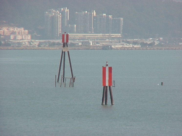
By day, range markers appear as signs having three vertical stripsstripes of two contrasting colors, and most are lit at night. These markers are placed such as to be aligned along the center of a preferred channel. If you are in the channel, the higher, farther away marker should appear to be directly above the lower, closer marker. If the markers are not aligned, you have strayed off-center. In the photo above, the vessel is to the port side of the channel.

[![example nautical chart having range markers][2]][2]example nautical chart having range markers
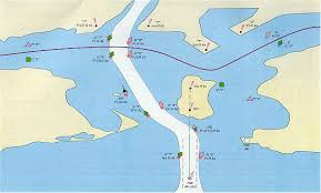
source: 13th Coast Guard District

When range markers are displayed on a nautical chart, such as the pair on the island in this fictitious example, there is also a dotted line drawn between them. Often this line is labeled with the true (as opposed to magnetic) bearing.


EDIT: I didn't know this before, but thanks to @Gabriel C., I learned that mcuhmuch of the above information is only applicable to the United States, where our Coast Guard maintains a standardized system of navigation aids. Apparently, in Canada, range markers look like this (trapezoid shapes):

[![range markers as they appear in Canada][3]][3]range markers as they appear in Canada
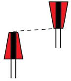
source: safeboat.ca

In other nations, range markers may follow other standards or no standards at all.

It might also be worth mentioning that some objects can form a range without being marked as such officialofficially, for example two unique buildingbuildings, one near shore and another on a hill just inland. Or a water tower and a bridge support. Many such things are shown on charts and serve as unofficial landmarks even though not meant for precise navigation. Draw a line between them on your chart, slide over to the compass rose to get the bearing between them, and when you see those objects lined up, you have your bearing. [1]: https://i.sstatic.net/zjOPU.png [2]: https://i.sstatic.net/jglpv.png [3]: https://i.sstatic.net/CJqCS.png

There is a type navigational aid that partially provides some bearing information, and that is a range marker. Such markers occur in pairs, positioned close enough together to both be seen at the same time, yet far enough apart to be visually distinct from each other. Further, the two markers are placed at different heights, so that one always appears above the other.

[![photograph of a pair of range markers in a harbor][1]][1] source: BoatUS

By day, range markers appear as signs having three vertical strips of two contrasting colors, and most are lit at night. These markers are placed such as to be aligned along the center of a preferred channel. If you are in the channel, the higher, farther away marker should appear to be directly above the lower, closer marker. If the markers are not aligned, you have strayed off-center. In the photo above, the vessel is to the port side of the channel.

[![example nautical chart having range markers][2]][2]

source: 13th Coast Guard District

When range markers are displayed on a nautical chart, such as the pair on the island in this fictitious example, there is also a dotted line drawn between them. Often this line is labeled with the true (as opposed to magnetic) bearing.


EDIT: I didn't know this before, but thanks to @Gabriel C., I learned that mcuh of the above information is only applicable to the United States, where our Coast Guard maintains a standardized system of navigation aids. Apparently, in Canada, range markers look like this (trapezoid shapes):

[![range markers as they appear in Canada][3]][3]

source: safeboat.ca

In other nations, range markers may follow other standards or no standards at all.

It might also be worth mentioning that some objects can form a range without being marked as such official, for example two unique building, one near shore and another on a hill just inland. Or a water tower and a bridge support. Many such things are shown on charts and serve as unofficial landmarks even though not meant for precise navigation. Draw a line between them on your chart, slide over to the compass rose to get the bearing between them, and when you see those objects lined up, you have your bearing. [1]: https://i.sstatic.net/zjOPU.png [2]: https://i.sstatic.net/jglpv.png [3]: https://i.sstatic.net/CJqCS.png

There is a of type navigational aid that partially provides some bearing information, and that is a range marker. Such markers occur in pairs, positioned close enough together to both be seen at the same time, yet far enough apart to be visually distinct from each other. Further, the two markers are placed at different heights, so that one always appears above the other.

photograph of a pair of range markers in a harbor source: BoatUS

By day, range markers appear as signs having three vertical stripes of two contrasting colors, and most are lit at night. These markers are placed such as to be aligned along the center of a preferred channel. If you are in the channel, the higher, farther away marker should appear to be directly above the lower, closer marker. If the markers are not aligned, you have strayed off-center. In the photo above, the vessel is to the port side of the channel.

example nautical chart having range markers

source: 13th Coast Guard District

When range markers are displayed on a nautical chart, such as the pair on the island in this fictitious example, there is also a dotted line drawn between them. Often this line is labeled with the true (as opposed to magnetic) bearing.


EDIT: I didn't know this before, but thanks to @Gabriel C., I learned that much of the above information is only applicable to the United States, where our Coast Guard maintains a standardized system of navigation aids. Apparently, in Canada, range markers look like this (trapezoid shapes):

range markers as they appear in Canada

source: safeboat.ca

In other nations, range markers may follow other standards or no standards at all.

It might also be worth mentioning that some objects can form a range without being marked as such officially, for example two unique buildings, one near shore and another on a hill just inland. Or a water tower and a bridge support. Many such things are shown on charts and serve as unofficial landmarks even though not meant for precise navigation. Draw a line between them on your chart, slide over to the compass rose to get the bearing between them, and when you see those objects lined up, you have your bearing.

added 1003 characters in body
Source Link
cobaltduck
  • 5.2k
  • 1
  • 19
  • 39

There is a type navigational aid that partially provides some bearing information, and that is a range marker. Such markers occur in pairs, positioned close enough together to both be seen at the same time, yet far enough apart to be visually distinct from each other. Further, the two markers are placed at different heights, so that one always appears above the other.

photograph of a pair of range markers in a harbor [![photograph of a pair of range markers in a harbor][1]][1] source: BoatUS

By day, range markers appear as signs having three vertical strips of two contrasting colors, and most are lit at night. These markers are placed such as to be aligned along the center of a preferred channel. If you are in the channel, the higher, farther away marker should appear to be directly above the lower, closer marker. If the markers are not aligned, you have strayed off-center. In the photo above, the vessel is to the port side of the channel.

example nautical chart having range markers [![example nautical chart having range markers][2]][2]

source: 13th Coast Guard District

When range markers are displayed on a nautical chart, such as the pair on the island in this fictitious example, there is also a dotted line drawn between them. Often this line is labeled with the true (as opposed to magnetic) bearing.


EDIT: I didn't know this before, but thanks to @Gabriel C., I learned that mcuh of the above information is only applicable to the United States, where our Coast Guard maintains a standardized system of navigation aids. Apparently, in Canada, range markers look like this (trapezoid shapes):

[![range markers as they appear in Canada][3]][3]

source: safeboat.ca

In other nations, range markers may follow other standards or no standards at all.

It might also be worth mentioning that some objects can form a range without being marked as such official, for example two unique building, one near shore and another on a hill just inland. Or a water tower and a bridge support. Many such things are shown on charts and serve as unofficial landmarks even though not meant for precise navigation. Draw a line between them on your chart, slide over to the compass rose to get the bearing between them, and when you see those objects lined up, you have your bearing. [1]: https://i.sstatic.net/zjOPU.png [2]: https://i.sstatic.net/jglpv.png [3]: https://i.sstatic.net/CJqCS.png

There is a type navigational aid that partially provides some bearing information, and that is a range marker. Such markers occur in pairs, positioned close enough together to both be seen at the same time, yet far enough apart to be visually distinct from each other. Further, the two markers are placed at different heights, so that one always appears above the other.

photograph of a pair of range markers in a harbor source: BoatUS

By day, range markers appear as signs having three vertical strips of two contrasting colors, and most are lit at night. These markers are placed such as to be aligned along the center of a preferred channel. If you are in the channel, the higher, farther away marker should appear to be directly above the lower, closer marker. If the markers are not aligned, you have strayed off-center. In the photo above, the vessel is to the port side of the channel.

example nautical chart having range markers

source: 13th Coast Guard District

When range markers are displayed on a nautical chart, such as the pair on the island in this fictitious example, there is also a dotted line drawn between them. Often this line is labeled with the true (as opposed to magnetic) bearing.

There is a type navigational aid that partially provides some bearing information, and that is a range marker. Such markers occur in pairs, positioned close enough together to both be seen at the same time, yet far enough apart to be visually distinct from each other. Further, the two markers are placed at different heights, so that one always appears above the other.

[![photograph of a pair of range markers in a harbor][1]][1] source: BoatUS

By day, range markers appear as signs having three vertical strips of two contrasting colors, and most are lit at night. These markers are placed such as to be aligned along the center of a preferred channel. If you are in the channel, the higher, farther away marker should appear to be directly above the lower, closer marker. If the markers are not aligned, you have strayed off-center. In the photo above, the vessel is to the port side of the channel.

[![example nautical chart having range markers][2]][2]

source: 13th Coast Guard District

When range markers are displayed on a nautical chart, such as the pair on the island in this fictitious example, there is also a dotted line drawn between them. Often this line is labeled with the true (as opposed to magnetic) bearing.


EDIT: I didn't know this before, but thanks to @Gabriel C., I learned that mcuh of the above information is only applicable to the United States, where our Coast Guard maintains a standardized system of navigation aids. Apparently, in Canada, range markers look like this (trapezoid shapes):

[![range markers as they appear in Canada][3]][3]

source: safeboat.ca

In other nations, range markers may follow other standards or no standards at all.

It might also be worth mentioning that some objects can form a range without being marked as such official, for example two unique building, one near shore and another on a hill just inland. Or a water tower and a bridge support. Many such things are shown on charts and serve as unofficial landmarks even though not meant for precise navigation. Draw a line between them on your chart, slide over to the compass rose to get the bearing between them, and when you see those objects lined up, you have your bearing. [1]: https://i.sstatic.net/zjOPU.png [2]: https://i.sstatic.net/jglpv.png [3]: https://i.sstatic.net/CJqCS.png

Source Link
cobaltduck
  • 5.2k
  • 1
  • 19
  • 39

There is a type navigational aid that partially provides some bearing information, and that is a range marker. Such markers occur in pairs, positioned close enough together to both be seen at the same time, yet far enough apart to be visually distinct from each other. Further, the two markers are placed at different heights, so that one always appears above the other.

photograph of a pair of range markers in a harbor source: BoatUS

By day, range markers appear as signs having three vertical strips of two contrasting colors, and most are lit at night. These markers are placed such as to be aligned along the center of a preferred channel. If you are in the channel, the higher, farther away marker should appear to be directly above the lower, closer marker. If the markers are not aligned, you have strayed off-center. In the photo above, the vessel is to the port side of the channel.

example nautical chart having range markers

source: 13th Coast Guard District

When range markers are displayed on a nautical chart, such as the pair on the island in this fictitious example, there is also a dotted line drawn between them. Often this line is labeled with the true (as opposed to magnetic) bearing.