There is a type navigational aid that partially provides some bearing information, and that is a range marker. Such markers occur in pairs, positioned close enough together to both be seen at the same time, yet far enough apart to be visually distinct from each other. Further, the two markers are placed at different heights, so that one always appears above the other.
By day, range markers appear as signs having three vertical strips of two contrasting colors, and most are lit at night. These markers are placed such as to be aligned along the center of a preferred channel. If you are in the channel, the higher, farther away marker should appear to be directly above the lower, closer marker. If the markers are not aligned, you have strayed off-center. In the photo above, the vessel is to the port side of the channel.
source: 13th Coast Guard District
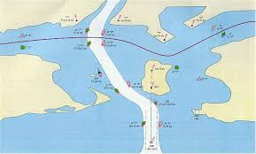
When range markers are displayed on a nautical chart, such as the pair on the island in this fictitious example, there is also a dotted line drawn between them. Often this line is labeled with the true (as opposed to magnetic) bearing.

