10

In planning my hikes, I would find it very useful to know where different types of forests are to be found across the map. Even having a basic distinction shown on the map between coniferous/needled forests (e.g. fir, pine) and deciduous/broadleaved forests (e.g. beech, oak) would be very helpful. For instance, it makes more sense to hike in pine forests on snowless winter days than in oak forests, if one has the choice.

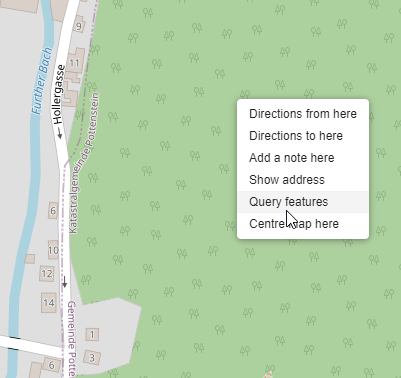
However, none of the major web-based mapping services I know of (Google Maps, OSM, Bing Maps, etc.) seem to offer this. OSM comes closest, in that it at least shows a repeating "forest" icon on the map:

enter image description here

However, even upon using "query features" for a given point on the map, the type of forest is never shown. Additional information is only shown for way types (paths, side-roads etc), but not for wild areas (shrubs, forests).

Pretty sure such mapping information on forest type exists at a smaller scale (e.g. local tourist maps, national park PDF maps, etc) - but is it also available on mapping websites that assemble such information over wide areas? Happy to pay for this service. My region of interest is Central Europe.
11
  • 1
    Does it explicitely need to be an online map? The paper hiking maps I'm used to always mark vegetation pretty well. (So maybe a solution would be electronic versions of them...) Commented Jan 2, 2022 at 10:20
  • 3
    What country are you in? The UK Ordnance Survey maps make this distinction both on their paper maps and on their app.
    – Darren
    Commented Jan 2, 2022 at 10:32
  • Also, all those services are totally inadequate for planning hikes in the country due to exactly the problem you’ve highlighted; a lack of paths and other details. You need to use maps specifically made for outdoors activities such as Harvey’s or OS in the UK (or whatever national mapping agencies or third-parties are available in your country), or the Viewranger app (or whatever it’s called now), for example.
    – Darren
    Commented Jan 2, 2022 at 10:36
  • @phipsgabler That would be acceptable too, as long as there was a single place where to get them (as scanned PDFs). But I suspect there isn't, at least not for beyond the county level or so.
    – z8080
    Commented Jan 2, 2022 at 20:36
  • 1
    If you have an area on google maps, you can go to satelite view, which will often be good enough to recognize tree kinds.
    – Willeke
    Commented Jan 2, 2022 at 21:26

3 Answers 3

15

OpenStreetMap

OpenStreetMap provides information about the type of forest. The information is stored in the tag leaf_type, which has the following values:

  • broadleaved
  • needleleaved
  • mixed
  • leafless

Besides this tag, you might also want to check out leaf cycle.

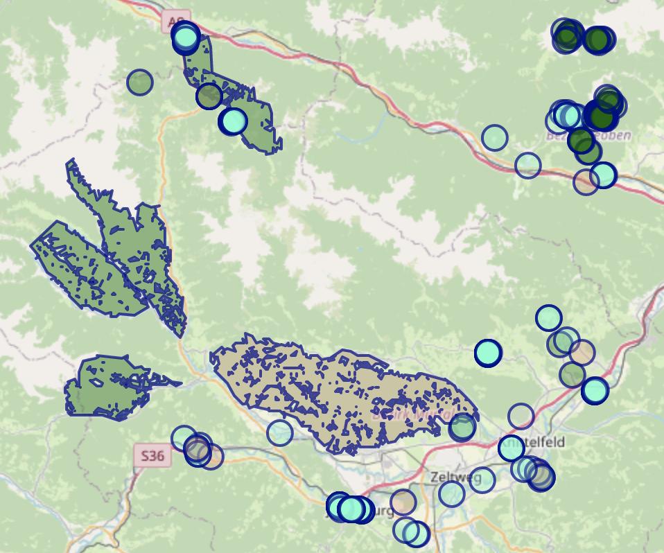
You can use the OverpassAPI to search for a certain type of forest. Using the web interface Overpass Turbo, it is possible to highlight search matches by leaf type on the map.

Overpass Turbo result

The following query searches usages of leaf_type in the visible map section and colors results by value.

[out:json][timeout:30];
(
  node["leaf_type"]({{bbox}});
  way["leaf_type"]({{bbox}});
  relation["leaf_type"]({{bbox}});
);
out body;
>;
out skel qt;

{{style:
  node[leaf_type=mixed], way[leaf_type=mixed], relation[leaf_type=mixed]
    { color:DarkBlue; fill-color:DarkSalmon; }

  node[leaf_type=needleleaved], way[leaf_type=needleleaved], relation[leaf_type=needleleaved]
    { color:DarkBlue; fill-color:DarkGreen; }

  node[leaf_type=broadleaved], way[leaf_type=broadleaved], relation[leaf_type=broadleaved]
    { color:DarkBlue; fill-color:Aquamarine; }

  node[leaf_type=leafless], way[leaf_type=leafless], relation[leaf_type=leafless]
    { color:DarkBlue; fill-color:LightGrey; }
}}

Other maps

The answer in "Official" providers of topographic maps per country lists map providers per country.

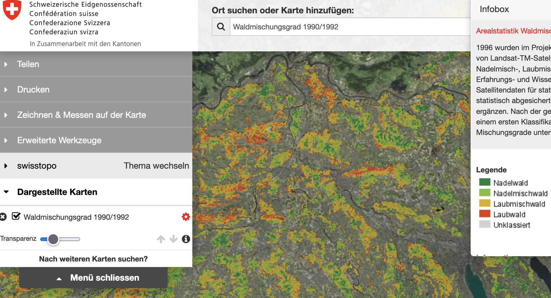
For example for Switzerland, Swiss topo allows displaying an overlay illustrating the type of forest. However, the information is from 1990/1992.

enter image description here

For Austria, AMAP Austria and Geoland do not seem to provide this information.

5
  • 1
    Amazing, thank you! Ironically, the screenshot I included actually did provide a clue as to the leaf type: it was a "mixed woodland" icon. So OSM does encode this after all - however, testing this for the case of woodlands I know well reveals this is not very accurate. For instance, the forest around St Egyden in Lower Austria is probably around 95% pine, yet it is unhelpfully shown as mixed. Another strange thing is that the leaf_type key/feature is NOT shown in Nearby Features, when doing a Query on a point in the woodland area!
    – z8080
    Commented Jan 3, 2022 at 10:05
  • 1
    The leaf_type tag should be shown when inspecting an object using "Query features" (example: openstreetmap.org/relation/13532864#map=14/46.7609/15.0112). However, the tag is not necessarily defined for all objects.
    – nrainer
    Commented Jan 3, 2022 at 10:17
  • 3
    There's also OpenTopoMap, which does a better job of rendering OSM as a topographical map. It may be respecting vegetation features more than openstreetmap.com, I don't know. But then it looks like most of Austria is defaulted to Mischwald... Commented Jan 3, 2022 at 10:20
  • 1
    Swisstopo is awesome! There is another forest map, "Wald swissTLM3D" under the Basiskarten, which is more recent and displays forest density. If you overlay that with the Waldmischung map, it is a pretty good picture. "Arealstatistik Bedeckung" might also be helpful. Commented Jan 3, 2022 at 13:16
  • 1
    @phipsgabler I also like OpenTopoMap, but for this OSM seems to use clearer symbols, and the cycling view can be used to provide contours. The underlying data is the same. Checking (logging in to OSM where I'm an occasional editor) a lot of what's tagged as mixed forest actually hasn't had the leaf type specified, so the default is implicitly "mixed". This is partly because a lot of forests at least in the UK are mapped as rather large areas, not broken down into individual plantations, and on that scale the one I cycled round yesterday would class as mixed.
    – Chris H
    Commented Jan 3, 2022 at 20:27
2

If the level of detail in printed topo maps satisfies you, then Outdooractive Pro seems to cover that, at least for some countries. It claims to have Swisstopo, Kompass, DAV/ÖAV, as well as a range of "digitalized official topo maps" which include DTK, ÖK, IGN, OS, Harvey, and some for Slovenia and Italy which I cannot really judge.

I haven't tried it myself, but you can set up a free trial account. (I'm not affiliated in any way with them.)

The only next level I can think of, besides satellite imagery (but you have that already on Google maps), are specialized cadastral maps for forestly like this one, but they are hard to find and too specialized to exist across countries and in publicated form.

2
  • thank you, that's very useful!
    – z8080
    Commented Jan 3, 2022 at 9:57
  • btw, just asked outdooractive support, and they do not offer forest-type information
    – z8080
    Commented Jan 3, 2022 at 10:39
1

For completeness, if you are in the UK then Ordnance Survey maps distinguish between coniferous and deciduous woods, as well as orchard and coppice.

0

Your Answer

By clicking “Post Your Answer”, you agree to our terms of service and acknowledge you have read our privacy policy.

Not the answer you're looking for? Browse other questions tagged or ask your own question.